Wisconsin Antique North America Maps & Atlases 1910-1919 Date Range
562 Results
Old 1913 Plat Atlas Map ~ MEDFORD Twp., TAYLOR Co., WISCONSIN
$34.000 bidsFree shippingEnding Today at 12:28PM PDT4h 4mOld 1913 Plat Atlas Map ~ GREENWOOD Twp., TAYLOR Co., WISCONSIN ~ Free S&H
$34.000 bidsFree shippingEnding Today at 12:30PM PDT4h 6m1916 WISCONSIN Map ORIGINAL Madison Green Bay Lake Superior Portage Ashland
$28.88Free shippingWisconsin, Grant County 1918 Plat Map Towns/ Clifton Lima Potosi village
$9.99$6.76 shippingOld 1913 Plat Atlas Map ~ BROWNING Twp., TAYLOR Co., WISCONSIN ~ Free S&H
$34.000 bidsFree shippingEnding Today at 1:27PM PDT5h 3mOld 1913 Plat Atlas Map ~ CHELSEA Twp., TAYLOR Co., WISCONSIN - CLARKE LAKES
$34.000 bidsFree shippingEnding Today at 1:33PM PDT5h 9mOld 1913 Plat Atlas Map ~ LITTLE BLACK Twp., TAYLOR Co., WISCONSIN
$34.000 bidsFree shippingEnding Today at 1:17PM PDT4h 53mOld 1913 Plat Atlas Map ~ GROVER Twp., TAYLOR Co., WISCONSIN - PERKINSTOWN
$34.000 bidsFree shippingEnding Today at 1:11PM PDT4h 47mOld 1913 Plat Atlas Map ~ WESTBORO & RIB LAKE Twp., TAYLOR Co., WISCONSIN
$34.002 bidsFree shippingEnding Today at 1:04PM PDT4h 40mNew Listing1913 Plat Atlas Map ~ Mc KINLEY Twp., TAYLOR Co., WISCONSIN - JUMP RIVER
$34.000 bidsFree shippingEnding May 15 at 5:20PM PDT4d 8hOld 1913 Plat Atlas Map ~ HOLWAY Twp., TAYLOR Co., WISCONSIN - TRAPPERS CREEK
$34.000 bidsFree shippingEnding Today at 1:43PM PDT5h 19mOld 1913 Plat Atlas Map ~ GOODRICH Twp., TAYLOR Co., WISCONSIN - RIB RIVER
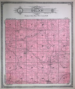
$34.000 bidsFree shippingEnding Today at 12:46PM PDT4h 22mOld 1915 Plat Map ~ SHELDON, OIL CITY, Twp., MONROE Co., WISCONSIN (LG14x17)
$45.95Was: $48.88Free shippingAntique 1914 Map Of Milwaukee Wisconsin 11x15 Inches
$19.50$4.68 shippingAntique 1914 Map Of Wisconsin 11x15 Inches
$19.50$4.68 shippingRipon Wisconsin 1918 Original Vintage USGS Topo Map
$39.95$3.50 shippingOld 1913 Plat Atlas Map ~ GILMAN, MURAT, LITTLE BLACK, TAYLOR Co., WISCONSIN
$34.000 bidsFree shippingEnding Today at 1:19PM PDT4h 55mOld 1913 Plat Atlas Map ~ Mc KINLEY Twp., TAYLOR Co., WISCONSIN - JUMP RIVER
$34.000 bidsFree shippingEnding Today at 12:22PM PDT3h 58mOld 1913 Plat Atlas Map ~ MAPLEHURST Twp., TAYLOR Co., WISCONSIN - BLACK RIVER
$34.000 bidsFree shippingEnding Today at 1:00PM PDT4h 36mOld 1913 Plat Atlas Map ~ RIB LAKE Twp., TAYLOR Co., WISCONSIN - WOOD LAKE
$34.000 bidsFree shippingEnding Today at 1:15PM PDT4h 51mOld 1913 Plat Atlas Map ~ WESTBORO Twp., TAYLOR Co., WISCONSIN - YELLOW RIVER
$34.000 bidsFree shippingEnding Today at 1:29PM PDT5h 5mOriginal 1915 Plat Map City West Bend Wis Bottling Works Railroad Canning Gehl
$22.50$6.50 shippingOld 1913 Plat Atlas Map ~ CLEVELAND Twp., TAYLOR Co., WISCONSIN - HANNIBAL
$34.000 bidsFree shippingEnding Today at 12:58PM PDT4h 34mOld 1913 Plat Atlas Map ~ MOLITOR Twp., TAYLOR Co., WISCONSIN - HULLS LAKE
$34.000 bidsFree shippingEnding Today at 1:51PM PDT5h 27mOriginal 1915 Plat Map City West Bend Wis Aluminum Co. Train Depot Brewery Nice
$22.50$6.50 shippingOld 1913 Plat Atlas Map ~ TAFT Twp., TAYLOR Co., WISCONSIN - BELLENGER
$34.000 bidsFree shippingEnding Today at 12:36PM PDT4h 12mOld 1913 Plat Atlas Map ~ RIB LAKE & GREENWOOD Twp., TAYLOR Co., WISCONSIN
$34.000 bidsFree shippingEnding Today at 1:31PM PDT5h 7mOld 1913 Plat Atlas Map ~ HAMMEL Twp., TAYLOR Co., WISCONSIN - MURAT
$34.000 bidsFree shippingEnding Today at 1:37PM PDT5h 13m1915 Antique WISCONSIN Miniature Atlas Map (8" x 5.5") Hammond's Handy Atlas
$6.17Was: $12.34$6.70 shippingVintage 1907 Atlas Plat Map ~ Geneva Township Walworth County Wisconsin #27
$69.99$3.50 shippingVintage 1916 Atlas Plat Map ~ Sheboygan Kohler Township County Wisconsin #29
$49.99$3.50 shipping1910 Color County Map State of Wisconsin and Missouri
$10.86$3.00 shippingOld 1913 Plat Atlas Map ~ AURORA Twp., TAYLOR Co., WISCONSIN - LUSK Sta. - POLLY
$34.000 bidsFree shippingEnding Today at 1:02PM PDT4h 38mAshland Bayfield Wisconsin WI Wis County Fold Out Maps 1917 ABSOLUTELY BEAUTIFUL
$99.99$6.00 shippingOriginal 1915 Plat Map City Of West Bend Wis WI North Part Water Tower Home Lots
$22.50$5.90 shippingOriginal 1915 Plat Map Town Of West Bend Nabob Cedar Lake Silver Lake Timmers
$22.50$6.50 shippingNew Listing1913 Plat Atlas Map ~ CLEVELAND Twp., TAYLOR Co., WISCONSIN - DONALD P.O.
$34.000 bidsFree shippingEnding May 15 at 12:23PM PDT4d 3hNew Listing1913 Plat Atlas Map ~ AURORA Twp., TAYLOR Co., WISCONSIN - GILMAN - YELLOW RIVER
$34.000 bidsFree shippingEnding May 15 at 2:00PM PDT4d 5h1912 ANTIQUE MAP OF NORTHERN USA NORTH SOUTH DAKOTA NEBRASKA IOWA WISCONSIN
$29.43$5.00 shipping1911 ANTIQUE MAP OF NORTH SOUTH DAKOTA MINNESOTA WISCONSIN / ONTARIO CANADA
$24.62$5.00 shippingWisconsin, Grant County 1918 Plat Map Towns of Paris & Harrison
$9.99$8.50 shipping1916 Standard Atlas of Lafayette County Wisconsin Plat Book Ogle
$200.00$7.83 shippingOld 1915 Plat Map ~ TOMAH, Twp., MONROE Co., WISCONSIN (LG14x17) Free S&H
$45.95Was: $48.88Free shipping1911 Antique Color Map Columbia County Wisconsin Portage Kilbourn 43X29 #0488
$29.80$4.13 shippingOld 1915 Plat Map ~ LA GRANGE, Twp., MONROE Co., WISCONSIN (LG14x17) Free S&H
$45.95Was: $48.88Free shipping1916 Standard Atlas of Lafayette County Wisconsin Plat Book Ogle
$225.00$7.83 shippingOld 1915 Plat Map ~ SOUTH PART of SPARTA Twp., MONROE Co., WISCONSIN (XLG17x29)
$45.95Was: $48.88Free shippingOld 1918 Plat Map ~ BRODHEAD Twp., WISCONSIN w/ CADIZ - JORDAN Twp. on Reverse
$45.95Was: $48.88Free shipping1915 Plat Map ~ GREENFIELD, TUNNEL CITY, Twp., MONROE Co., WISCONSIN (LG14x17)
$45.95Was: $48.88Free shipping1916 SOUTH MILWAUKEE HARBOR WISCONSIN ENGINEERING MAP 9 x 13.75!
$9.99$5.25 shipping1911 Antique Rand McNally Map of WISCONSIN w/copy History/Demographics
$12.95$5.25 shippingVintage 1907 Atlas Plat Map ~ Bloomfield Township Walworth County Wisconsin #39
$69.99$3.50 shippingVintage 1907 Atlas Plat Map ~ Richmond Township Walworth County Wisconsin #17
$59.99$3.50 shipping